The Google Maps Embed Pack includes 5 formulas to make it easier to embed maps in your Coda docs:
-
Place(): Displays a map pin at a particular place or address, such as a landmark, business, geographic feature, or town.
-
View(): Returns a map with no markers or directions.
-
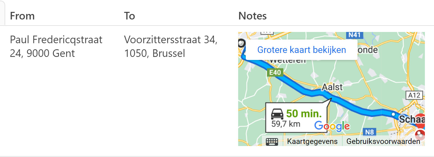
Directions(): Displays the path between two or more specified points on the map, as well as the distance and travel time.
-
StreetView(): Shows interactive panoramic views from designated locations.
-
Search(): Shows results for a search across the visible map region.
You can learn more here → Coda | Google Maps Embed
Will start to investigate the possibility to include additional Google Maps APIs, either by you providing your own API key or doing a credit/usage based Pack where you buy credits and then can use them against the API 
10 Likes
@Leandro_Zubrezki, dude, you are a MACHINE !
yet another extremely useful pack
keep up the good work !
max
2 Likes
hi @Leandro_Zubrezki , it is a nice start. I assumed to get back in Coda the travel time and distance in numeric values to manipulate, not as data on the map, see below. Is that in the planning?
Cheers, Christiaan
2 Likes
Hi @Christiaan_Huizer !
Google Maps provides different APIs, Maps Embed, Maps Static, Directions, Distance Matrix, Geocoding and Place Details, among others!
From those APIs the only one free and unlimited is Maps Embed, the one currently available in the Pack. The rest of them are usage based, you get charged based on the number of requests you make to the API to get data back from Google Maps, as an example 1.000 Geocoding requests is $5.
The idea is to add support for additional APIs, providing your own API key or implementing a credit mechanism, you buy $10 of credits to do x number of requests. In both cases transparency on the cost of each operation will be important.
Hope that clears the doubts and the why the Maps API is difficult to work with 
3 Likes
thx for the feedback, well I own https://place.guru and know very well what you are talking about. It is a costly business with Google.
2 Likes
Nice! Just created an account to take a look  , and yes, it is costly and the pricing is pretty difficult for reselling, but I will come up with something!
1 Like
Any ability yet to produce multiple map pins on the same map? i.e. a list of locations from a table
1 Like
@JoshSzwarga unfortunately it is a case that is not supported by the Google Maps Embed API. The best you can do is use the Directions formula and passing the list of places.
2 Likes
I have so many use cases for this and can’t wait to practice with it! Thank you!
2 Likes
this is great, do you plan to include soon the option to connect to the maps api that gives you information on distance, time… ? Thanks a lot
2 Likes
Hi @Ximo_Escamilla, welcome back to the community!
Unfortunately those are paid features of the Google Maps API that are charged by usage and at the moment it would be difficult to implement as a public Pack, maybe in the future 
2 Likes
Found a trick to put multiple pins on an interactive map using your pack:
2 Likes
Awesome @Rickard_Abraham ! Will investigate more and add it to the playground
2 Likes
@Leandro_Zubrezki I’m starting to play around with this pack for a doc I am creating to plan a roadtrip. Can you tell me the syntax for using more than one waypoints using the Directions() map?
1 Like
It’s just a list of strings, see my embed two replies up
2 Likes
As Rickard mentions (thanks!) it is a list of strings: Directions("Address 1", "Address 2", waypoints: List("Address 3", "Address 4"))
2 Likes
Thanks @Rickard_Abraham and @Leandro_Zubrezki . I just wasn’t putting a parenthese around the multiple waypoints to create the string.
3 Likes
Hi ,
tried to make it works I got almost everything with my API key but I cannot get distances and time…
While it’s written " Directions Displays the path between two or more specified points on the map, as well as the distance and travel time." I see the same problem in the map coming with the Pack, There is no path, no distance or time shown so I wanted to ask if there is another way to get those details?
Thanks
1 Like
Hi @Anthony_Fernandez_Ferrandiz !
Have you checked and copied the playground? This is the link and how it looks:
1 Like
Hi, I put you here a screen capture of your webpage when I just arrive on the page.
As you can it’s not posible to see informations as in yours cause of the zoom factor.
Now, zoomin into I get this

Sorry…
Just what I also get when I use your pack into my own pages…

And I forgot to say I’m looking for something that would return informations like distance, time etc
Would be very interesting to have a function allowing us to not only show an image but also to retrieve informations…
Anyway, thank you for this pack.
–
Anthony
1 Like